Smarter Drones Need 5G for A.I.
Unmanned aerial vehicles (UAVs), or drones, have come a long way since the first low-cost systems emerged in 2007. They have been used for a wide variety of exciting and forward-thinking private and commercial purposes since the Federal Aviation Administration (FAA) issued the first commercial drone permit in 2006.
Drones have gained mass popularity just in the last few years as they’ve become smaller, more affordable and more innovative. When they entered the commercial market, drones were primarily used for taking photos and videos as veritable eyes in the sky, both indoors and out — collecting data near and far on nearly everything from weather patterns to crime scenes.
As artificial intelligence (A.I.) capabilities and demand for low-altitude drones increase, the need to maintain constant connectivity and efficiency has never been more important. So is the ability for a drone to fly beyond the visual line of sight — going past the pilot’s visual range and flying further distances without human interference.
InvisiLight® Solution for Deploying Fiber
April 2, 2022Go to Market Faster. Speed up Network Deployment
April 2, 2022Episode 10: Fiber Optic Closure Specs Explained…
April 1, 2022Food for Thought from Our 2022 ICT Visionaries
April 1, 2022The question now is about overall performance. Is a cellular data network a robust enough connectivity option to maintain drone communication beyond the visual line of sight? Or is satellite communication (SATCOM) still the only viable option for autonomous, low-altitude drones that operate at or below 400 feet?
Let’s first lay 2 misconceptions to rest:
1. Cellular coverage is not available at altitudes greater than 400 feet.
2. SATCOM is the only option for drones to go beyond the visual line of sight.
As drones fly higher, cell towers become visible — offering extraordinary throughput and connectivity hundreds of feet in the air. Even as early as 2017, Qualcomm Technologies’ LTE Unmanned Aircraft Systems (UAS) trial showed strong downlink (DL), uplink (UL), and handover signal capabilities in low-altitude drone performance at a range of altitudes up to 400 feet in 3 different LTE bands. Despite the assumption that down-tilted antennas would weaken signals to airborne users, a clear line of sight path made up for antenna gain reductions and proved that cellular networks can deliver high-performing drone connectivity.
While SATCOM does offer high-bandwidth connectivity for drones from Low Earth Orbit (LEO), Medium Earth Orbit (MEO) and Geostationary Earth Orbit (GEO) satellites, it’s no longer the only connectivity option for successfully flying low-altitude drones beyond the line of sight.
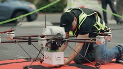
Uber Eats successfully conducted its first food delivery by drone in 2019 in a high-density urban area.
5G Is Drone Heaven
With wide-area, high-speed, secure wireless network coverage from major wireless service providers available nearly everywhere a drone can go, networks like 4G LTE and 5G support safe, reliable autonomous drone operation beyond the visual line of sight. 5G is not only the present and future of connectivity, but it also enables wide-scale drone deployment for mission-critical drone use cases like search and rescue missions, air traffic management, and capturing 360-degree virtual reality footage.
With 5G, A.I.-enabled drones have advanced perception capabilities and can report data in real time, which is crucial when it matters most. Whether a drone is being used to drop medical supplies or to deliver food or packages, the ability to rely on knowing what’s happening and when could be a life saver.
A.I.-enabled drones can be flown safely and reliably indoors and outdoors for a wide variety of use cases, such as:
• Crop monitoring and soil assessment in farming and agriculture
• Terrain scanning and equipment positioning for construction
• Structural and underground inspection
• Smart city security surveillance
• Area mapping for urban planning
• Emergency response
• Human tracking and facial recognition
• Detecting danger and monitoring security in unsafe environments
• Inventory management in warehouses
• Delivering food and supplies
• Border patrolling, security monitoring, storm tracking, supplying food, and safety inspection for the military and defense
Uber Eats successfully conducted its first food delivery by drone in 2019 in a high-density urban area, where tall buildings and flight distance created challenges. The drone used a powerful, lightweight computing platform with 4G connectivity to stay on the flight path safely while out of the commanding pilot’s sight, proving that cellular connectivity can reliably support drone flights beyond the visual line of sight.
The U.S. military is using A.I.-powered drones with cellular technology as well. The Department of Defense (DoD) Defense Innovation Unit is using A.I.-enabled drones with 4G LTE technology to successfully execute U.S. Army missions that will ultimately save lives. They are using computer-vision-based navigation which helps armed forces safely and reliably use unmanned aircraft systems wherever they need them, instead of using a GPS-exclusive system that could run the risk of losing satellite connectivity.
Ideal Drone Building
Depending on the end purpose of the drone being built, engineers want to consider several must-have features for optimum performance, including:
• 4G LTE and/or 5G cellular technology for flying beyond the visual line of sight
• A virtual private network (VPN) for security and multiple-device networking
• A.I. for movement and perception capabilities, such as Simultaneous Localization and Mapping (SLAM) to orient the drone to its ever-changing surroundings, and to plan mission paths and facilitate obstacle avoidance with deep learning object recognition and integrated depth sensing
• Visual inertial odometry (VIO) for estimating device positioning
• Flexible software architecture for easier development
• Support for multiple image sensors for simultaneous 4k video capture, streaming, and computer vision processing
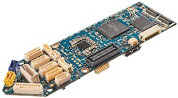
• Generous computing capacity on a single printed circuit board (PCB) for a lightweight, cost-effective, plug-and-play solution
VOXL Flight is the first open-source development platform for safe, autonomous drone navigation that utilizes the smartphone ecosystem and all the essential and advanced technologies on one lightweight printed circuit board PCB.
Military drone developers are also required to use components made outside of China, ideally in the US, to be compliant with the National Defense Authorization Act of 2020. The Act states that the DoD cannot use or renew a contract for a foreign-made UAS that was manufactured in, uses equipment like cameras or flight controllers, or employs a ground control system developed in or utilizes a network or data storage administered by China or an entity domiciled in China.
In addition to supporting American-made technology, this rule offers reliable advantages including quality control, safety, documentation, expedited timelines for development, state-of-the-art innovation, and reliable support as needed.
As technology continues to improve the performance of all things, advancements in A.I. and connectivity also evolves. Forward-looking engineers rely on those advancements to continuously improve capabilities and increase use cases for drones — making them smarter, safer, and more capable, every day. One company on the forefront of designing and manufacturing A.I.-powered modules that communicate on 4G and 5G cellular networks for use beyond the line of sight is ModalAI®.
Like this Article?
Subscribe to ISE magazine and start receiving your FREE monthly copy today!
References and Notes
Read more about drone radios for enterprise use cases.
https://arxiv.org/pdf/1812.02792.pdf
https://arxiv.org/pdf/1707.07534.pdf
https://www.unmannedairspace.info/uncategorized/drones-need-cellular-networks-for-full-service-autonomous-operations-and-utm-gutma-connected-skies-webinar/
https://builtin.com/artificial-intelligence/drones-ai-companies
https://medium.com/vsinghbisen/how-ai-based-drone-works-artificial-intelligence-drone-use-cases-7f3d44b8abe3
https://www.nature.com/articles/d42473-019-00304-3
https://www.ncbi.nlm.nih.gov/pmc/articles/PMC6929112/
https://www.qualcomm.com/media/documents/files/leading-the-world-to-5g-evolving-cellular-technologies-for-safer-drone-operation.pdf
https://www.qualcomm.com/media/documents/files/lte-unmanned-aircraft-systems-trial-report.pdf
Sources:
https://arxiv.org/pdf/1812.02792.pdf
https://arxiv.org/pdf/1707.07534.pdf
https://www.unmannedairspace.info/uncategorized/drones-need-cellular-networks-for-full-service-autonomous-operations-and-utm-gutma-connected-skies-webinar/
https://builtin.com/artificial-intelligence/drones-ai-companies
https://medium.com/vsinghbisen/how-ai-based-drone-works-artificial-intelligence-drone-use-cases-7f3d44b8abe3
https://www.nature.com/articles/d42473-019-00304-3
https://www.ncbi.nlm.nih.gov/pmc/articles/PMC6929112/
https://www.qualcomm.com/media/documents/files/leading-the-world-to-5g-evolving-cellular-technologies-for-safer-drone-operation.pdf
https://www.qualcomm.com/media/documents/files/lte-unmanned-aircraft-systems-trial-report.pdf


