Capturing Geospatial Data for Fiber-to-the-Home Rollouts in Days Versus Weeks
The surge in Fiber-to-the-home or FTTH investments is representative of the global drive towards digital inclusivity and economic prosperity. In North America, the Broadband Equity, Access and Deployment (BEAD) program is allocating $42.45 billion to expand high-speed internet access across all states and territories. In Canada, the Universal Broadband Fund has earmarked $3.225 billion to expand FTTH coverage, aiming to reach every Canadian household by 2030.
Within Ontario, as many as 700,000 households—approximately 1.4 million Ontarians— live with inadequate or nonexistent internet connectivity. To resolve this issue, the Government of Ontario has pledged nearly $4 billion to achieve universal coverage by 2025. Eight Internet Service Providers (ISPs) are working on FTTH projects in different regions of Ontario through the Accelerated High Speed Internet Program (AHSIP).
Meticulous planning and accurate data are crucial to the success of these far-reaching FTTH projects. According to the FTTH Handbook (Edition 9) written by the FTTH Council Europe, comprehensive background mapping data forms the basis of network architecture design. While that data can come from national mapping agencies and GIS vendors, an increasingly common source of data is mobile mapping systems.
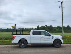
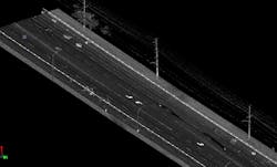
The development of mobile mapping systems has revolutionized data acquisition. Advanced lasers can capture up to one million points per second at centimeter-level accuracy while traveling at posted speeds. These ultra dense point clouds provide a complete view of real-world conditions, minimizing the need for field visits and ensuring up-to-date information for informed decision making.
Landbase as the Foundation
Planview Utility Services Ltd. (Planview USL) provides engineering services, GIS and mapping services, subsurface utility engineering, and asset management services to some of the largest utilities and municipalities in Ontario, including several of the ISPs participating in the AHSIP. Planview USL has collected over 18,000 kilometers of comprehensive point clouds and imagery, laying the groundwork for designing FTTH networks in underserved rural communities.
The success of the project relies on careful pre-planning to identify difficult terrain and potential infrastructure gaps (such as inadequate telephone poles and underground conduits), and to schedule work within the time constraints of a short construction season.
Tony D’Amico, Director GIS Services, Solutions & Mobile Mapping at Planview USL, emphasizes the importance of mobile mapping in overcoming logistical hurdles. "In our vast province, reaching remote areas poses a significant challenge. Mobile mapping allows us to gather a large volume of data quickly during the summer months, followed by processing in the winter months," says D'Amico.
Improving Efficiency and Reducing Cost
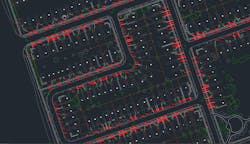
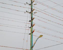
Leveraging mobile mapping systems offers many operational benefits to FTTH projects. These systems expedite the collection of georeferenced point clouds and imagery, which can be used for multiple tasks such as visual asset inspections, ad-hoc measurements, and vegetation management. The comprehensive landbase derived from this data supports service area analysis, map generation, 360° imagery creation, and seamless integration into GIS platforms.
Employing a vehicle equipped with a mobile mapping system allows for efficient data collection at posted driving speeds, managed by a two-person team capable of covering an average of 150 to 200 km per day. In a span of five days, this technology can gather data over 750–1,000 km, compared to several hundred kilometers within the same timeframe using traditional terrestrial equipment. Costs associated with accommodations, meals, and travel time are reduced due to fewer personnel, which is especially beneficial when operating in remote rural areas.
Furthermore, the adoption of mobile mapping technology has opened up new opportunities for Planview USL. The mobile lidar team has grown in both size and resources to meet increasing demand from telecommunications companies and other engineering firms.
Empowering Underserved Communities
Providing high-speed internet connectivity to every household and business is instrumental in bridging the digital divide, particularly in remote and rural areas. The Government of Ontario's initiative to expand FTTH infrastructure will improve access and create new opportunities for video streaming, cloud computing, virtual reality, remote work, online education, and more.
Linda Duffy is a freelance writer and market researcher at Apropos Research, an independent firm providing marketing services to the geospatial and remote sensing community since 2003. Contact: [email protected].
About the Author
Linda Duffy
Linda Duffy is a freelance writer and market researcher at Apropos Research, an independent firm providing marketing services to the geospatial and remote sensing community since 2003. Contact: [email protected].


