Latest from Home
Answering the Service Availability Question —
The ability to answer the service availability question quickly is an effective and relatively low-cost way to increase revenue. However, for most telecommunications companies, presenting a quick and accurate cost quote for business service requests is a significant challenge.
One telecommunications company that was expanding into new business markets estimated that it lost 60% of potential clients because it took from 3 to 7 business days to determine whether the company could provide fiber-based service.
Demand for such services is increasing, and providing a price quote requires determining the client’s proximity to the nearest network access point, and then estimating the cost to construct a network extension. Unless staff are using a GIS-based tool, determining an accurate cost estimate is a manual process that requires the sales team to submit a request to the engineering department.
Automated Service Quotes
Companies need a tool for the sales team to instantaneously deliver an accurate cost quote to the client. Since determining the quote requires spatial analysis, GIS is an ideal technology.
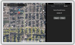
Within the GIS, you create a model that emulates the manual process the engineering estimator would otherwise follow. Access to the system is provided via a mobile app. The sales agent inputs the service type and customer location. The GIS runs the analysis and instantaneously displays the cost estimate. (See Figure 1.)
Figure 1.
This type of solution brings speed, consistency, and accuracy to the process, allowing the sales agent to close the deal before departing from the client’s site.
How It Works
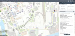
The key to fast and accurate cost quotes is using GIS to access network and geographic data to determine the optimal route connecting the customer location to the most appropriate network access point. The solution assesses the available paths and selects routes that avoid railroad crossings, rivers, and other barriers. (See Figure 2.) It can be designed to leverage existing infrastructure, reducing cost, and speeding construction. Most importantly, the model used for route selection and cost estimates is designed and controlled by the engineering department.
Figure 2.
The Competitive Advantage
A GIS-based spatial model offers several advantages over the manual processes it replaces:
• It provides speed and consistency.
• Quotes that could take hours to manually produce can be delivered in seconds.
• Since the quote is model-based, there are no variations in the output.
• Providing fast, accurate quotes during initial contact with your customers instills them with the confidence that you can deliver services on time and within budget.
• Companies are also using GIS models for backhaul planning and bulk wireless coverage analysis.
GIS models can provide cost quotes for any type of service or network technology.
For more information on GIS modeling and service cost analysis, please email [email protected] or visit www.esri.com/ISEMag.


